Showing posts with label Geography. Show all posts

Thursday, October 19, 2006

potala palace 布达拉宫


in 641, after marrying princess wencheng, songtsen gampo decided to build a grand palace to accommodate her and let his descendants remember the event. however, the original palace was destroyed due to a lightening strike and succeeding warfare during landama's reign. in seventeenth century under the reign of the fifth dalai lama, potala was rebuilt. the thirteenth dalai lama expanded it to today's scale. the monastery-like palace, reclining against and capping red hill, was the religious and political center of old tibet and the winter palace of dalai lamas. the palace is more than 117 meters (384 feet) in height and 360 (1180 feet) in width, occupying a building space of 90 thousand square meters. potala is composed of white palace and red palace. the former is for secular use while the later is for religious.

  the white palace consists of offices, dormitories, a buddhist official seminary and a printing house. from the east entrance of the palace, painted with images of four heavenly kings, a broad corridor upwards leads to deyang shar courtyard, which used to be where dalai lamas watched operas. around the large and open courtyard, there used to be a seminary and dormitories. west of the courtyard is the white palace. there are three ladder stairs reaching inside of it, however, the central one was reserved for only dalai lamas and central government magistrates dispatched to tibet. in the first hallway, there are huge murals describing the construction of potala palace and jokhang temple and the procession of princess wencheng reaching tibet. on the south wall, visitors will see an edict signed with the great fifth's handprint. the white palace mainly serves as the political headquarter and dalai lamas' living quarters. the west chamber of sunshine and the east chamber of sunshine lie as the roof of the white palace. they belonged to the thirteenth dalai lama and the fourteenth dalai lama respectively. beneath the east chamber of sunshine is the largest hall in the white palace, where dalai lamas ascended throne and ruled tibet.

  the red palace was constructed after the death of the fifth dalai lama. the center of the complicated red palace is the great west hall, which records the great fifth dalai lama's life by its fine murals. the scene of his visit to emperor shunzhi in beijing in 1652 is extraordinarily vivid. it also has finely carved columns and brackets. the hall has four additional chapels. the west chapel houses three gold stupas of the fifth, tenth and twelfth dalai lamas'. their mummified and perfumed bodies are well kept in those stupas. among the three, the fifth dalai lama's stupa is the biggest, which is made of sandalwood, wrapped in gold foil and decorated with thousands of diamonds, pearls, agates and others gems. the stupa, with a height of 14.86 meters (49 feet), spends more than 3,700 kilograms of gold. the north chapel contains statues of sakyamuni, dalai lamas and medicine buddha, and stupas of the eighth, ninth and eleventh dalai lamas. against the wall is tanjur (beijing edition), a most important tibetan buddhist sutra sent to the seventh dalai lama by emperor yongzheng. in the east chapel a two meters (6.5 feet) high statue of tsong khapa, the founder of gelugpa which is dalai lama's lineage, is enshrined and worshipped. in addition, about 70 famous adepts in tibetan buddhism surround him. the south chapel is where a silver statue of padmasambhava and 8 bronze statues of his reincarnations are enshrined. on the floor above, there is a gallery which has a collection of 698 murals, portraying buddhas, bodhisattvas, dalai lamas and great adepts and narrating jataka stories and significant tibetan historic events. west of the great west hall locates the thirteenth dalai lama's stupa hall. since he was regarded as great as the great fifth, people started to build his stupa after his death in the fall of 1933. taking three years, the stupa is comparable with the great fifth's stupa. it is 14 meters (46 feet) in height, coated with a ton (2200 pounds) of gold foils. in front of it is a mandala made of more than 200,000 pearls and other gems. murals in the hall tell important events in his life, including his visit with emperor guangxu. the highest hall of potala was built in 1690. it used to be the holy shrine of chinese emperors. dalai lamas would come here with his officials and high lamas to show their respects to the central government annually before.

  dharma cave and the saint's chapel are the only structures left which were built in seventh century. they both lie central of the red palace. dharma cave is said to be the place where king songtsen gampo proceeded his religious cultivation. inside the cave, statues of songtsen gampo, princess wencheng, princess tritsun and his chief ministers are enshrined. in the saint's chapel above dharma cave, chenrezi, tsong khapa, padmasambhava, the fifth, seventh, eighth and ninth dalai lamas are enshrined and worshipped. visitors may find a stone with a footprint that was believed left by the infant twelfth dalai lama.

  notes:

  1. potala palace 布达拉宫

  2. princess wencheng 文成公主

  3. songtsen gampo 松赞干布

  4. white palace 白宫

  5. red palace 红宫
Google Maps,Google Maps coordinate,Only show at Item-Page.


布达拉宫是一座融宫堡和寺院于一体的古建筑群,始建于公元七世纪四十年代松蕃王朝松赞干布时期,距今已有一千三百多年历史。它座落在西藏自治区首府拉萨市中心、古城西北约2公里的玛布山(红山)上,最高处海拔3767.19米,是世界上海拔最高的古代宫殿。

1961年国务院将布达拉宫列为全国重点文物保护单位。19XX年,布达拉宫被确认为世界文化遗产。

布达拉宫是西藏自治区内最完整最宏伟的一座古建筑。“布达拉”是普陀罗(普陀)的译音,意即菩萨住的宫殿,相传公元七世纪时,吐蕃赞普松赞干布与唐联姻,为迎娶文成公主而建成此宫,今尚存法王修法洞和观音佛堂两处早期建筑。现有建筑群为17世纪中叶五世达赖受清朝册封后开始兴建,并经过历代达赖不断扩建而成。1959年前,布达拉宫是五世达赖之后历代达赖喇嘛生活起居和从事政治活动的场所,是旧西藏政教合一的统治权力中心,从七世纪起,先后共有九个赞普 (藏王)和十位达赖在这里居住过。

布达拉宫由红山南麓奠基,缘山而上,依势迭砌,从平地直达山顶,几乎占了整座玛布山(红山)。布达拉宫高117米,东西长360米,外观13层,实为9层,面积约12万平方米,殿宇巍峨,金顶辉煌,共有佛堂、经堂、灵塔殿、习经室 15000多间(按西藏建筑计算办法以柱计算)。整个建筑系石木结构。用块块方石垒砌,高大宽敞的殿堂墙上绘有各种色彩鲜艳的壁画,室内陈设有几十万个用金、银、铜、玉和檀香木等雕铸的大小佛像,造型生动。集中体现了藏族人民高度的建筑成就和独特的艺术风格。

宫城占地41公顷,包括四大部分:红山之上的红宫、白宫、山后的龙王潭和山脚下的“雪”。其中红宫为历代达赖的灵塔殿和各类佛堂,位于整个建筑的中心和顶点,也是须弥佛土和宇宙中心的象征;白宫合抱于红宫外侧,是历代达赖的宫殿、大经堂、噶厦政府机构和僧官学校等,达赖的寝宫位于白宫最高处,又称日光殿;龙王潭为布达拉宫后园,方圆3公里,中为湖,湖中小岛上建有龙王宫和大象房等;“雪”在布达拉宫脚下,其中安置有噶厦政府的监狱、印经所、作坊、马厩,周围是宫墙和碉堡。站在红山脚下,可以看到布达拉宫的整体布局,由下到上分别是“雪”、白宫和红宫,充分体现了藏传佛教中“欲界”、“色界”、“无色界”的“三界说”,通过建筑布局艺术的对比、夸张和渲染,表现了佛法的神威,令人在千年之下,仍望之而生对天国佛境的凛遵之感……

布达拉宫是全国重点文物保护单位之一,红宫白宫内珍藏无数。一年四季开放。开放时间和当地企事业机关办公时间相同。每当藏历新年前一天会有跳神活动。

Tuesday, October 10, 2006

Guilin(桂林山水) - Amazing Landscape

Taking a trip into the hully karst landscape of Guilin at sunset is one of the most breath-taking site in China. Guilin by the banks of the Li River in southern China is justifiably considered to be one of the most beautiful in China. Today, Guilin attracts innumerable tourists because of its unique landscape. Until the end of the 1970s, it was a quiet, sleepy area. Since then, Guilin and the settlements along the Li River have undergone an incredible development through tourism. This town with over 400,000 inhabitants acquired its name from the Cassia trees, whose blooms carry their sweet scent through the whole town in autumn. Guilin literally means "Cassia Tree Forest". Guilin is said to be founded in 214 BC. At that time, the Lingqu Canal was built under the regency of the first Chinese emperor, Qin Sin Huangdi. It still connects the central Asian plain with southern China, and South-East Asia, via the Yangzi, the Lijiang and the Pearl river. Guilin and its surroundings are still mostly agricultural, but this is limited by the numerous mountains which pose a problem in the whole of Guangxi region. The landscape is characterised by terraced rice paddies, water buffalos, and bamboo groves, and peasants with turn up trousers and cone-shaped straw hats. Guilin is famous for it spicy Guilinjiang, a type of pepper sauce. From the Mountain of Coloured Layers, a 223 metre high mountain on the north, visitors can get a wonderful view of Guilin and Lijiang. The most beautiful tourist spot is the Crystal Palace of Dragon King, in the Reed Flute Cave at north west of the city centre and a subterranean water landscape, which resembles the landscape around Guilin and the Li River.
A boat trip on the peaceful Li River is the absolute high point of any visit to Guilin. A cruise from Guilin to Yangshuo, visitors will experience the winding and twisting Li River, goes past the many bizarre mountains whose shapes have inspired and fired the Chinese imagination, the Elephant Trunk Mountain, Old Man Mountain, Pagoda Mountain and Hole Mountain. Cormorant fishermen in narrow bamboo boats, bathing children, water buffaloes, small settlement and women doing their washing on the banks of the river can be seen along the way. Yangshuo, at the end of the boat journey is today a developed village that thrives mainly on tourism and seems to have nothing but tourist shops.

North-east of Guilin is Sanjiang, a settlement of the Song people. Changyong Bridge is an architecturally unique sight. South-west of Guilin, in the centre of the Autonomous region of Guangxi is Linzhou with 600,000 inhabitants, is an expanding industrial town, pricturesque and typically southern Chinese. The main attraction is the Dule Rock with its numerous karst caves. Another area with a beautiful landscape is the settlement of Guiping. The capital of the Autonomous Region of Guangxi is Nanning. It is located deep in the south and is only 160 km from the Vietnamese border. South-west of Nanning, near the Vietnamese border by the river Zuojiang, is a landscape as fantastic as that in Guilin. In Ningmeng county, visitors can see a 1,700 year old mysterious rock painting along a steep rock face by taking a boat on Zuojiang river.

Google Maps,Google Maps coordinate,Only show at Item-Page.


地理位置

1、地理位置:桂林是世界著名的风景旅游城市和历史文化名城,地处南岭山系西南部,广西壮族自治区东北部,109°45''-104°40'',北纬24°18''-25°41''。
  2、行政区划:辖秀峰,象山,七星,叠彩,雁山5城区和灵川,兴安,全州,临桂,阳朔,平乐,荔浦,龙胜,永福,恭城,资源,灌阳12个县,行政区域总面积27809平方公里。其中市区面积565平方公里。

  城市历史

  桂林历史悠久。根据市区宝积岩和甑皮岩洞穴发现的遗物,经考证,甑皮岩人已进入母系氏族社会阶段,距今约一万年。
  夏商周时期,这里是“百越”人的居住地。秦始皇置桂林,象,南海三郡,这是“桂林”名称的最早起源,但郡治不在今天的桂林市。汉元鼎六年(公元前111年),在这里设始安县,隶属荆州零陵郡。东汉时改属始安侯国。三国时先属蜀,后归吴。甘露元年(265年),置始安郡始安县,郡县治所都在今之桂林。隋唐时属岭南桂州总管府。唐武德四年(621年),李靖修城于独秀峰南。贞观八年(634年)改名临桂县,属桂州始安郡。光化三年(900年)始,属静江节度。五代十国时先后属楚和南汉的桂州。宋时,前属广南西路桂州,后属静江府。元时属广西行中书省静江路。明清时均属广西省桂林府。民国时属广西省。1914年改名桂林县,1940年始设桂林市。1944年11月至1945年7月28日,为日寇占领。光复后仍为广西省辖市。历史上长期为广西省会。   1949年11月22日桂林解放,为广西省辖市,1958年改称广西壮族自治区桂林市,辖桂林城区和郊区。
  1981年7月、1983年10月阳朔、临桂划归桂林市管辖。
  1996年12月26日桂林市委,市人民政府按国务院,自治区批复的方案,实行区划调整,将郊区更名为雁山区。
  1998年9月8日经国务院批准,桂林市和桂林地区合并,组建新的桂林市。More

Monday, October 09, 2006

The History of The Great Wall(长城)

The Great Wall is well-known because of its magnificent majestic appearance.Now,in the call of "Loving our China, repairing our Great Wall", many places of The Great Wall have be repaired, which make it more boundless. The Great Wall has become the head key point of interest in China. more and more foreign people was attracted by it. The people who visited it are all acclaim as the peak of perfection.
 The Great Wall convolves on the ridges of mountains and desert.It's maked up of city gates,circumvallations, enemy towers,signal beacon towers and so on, it was the martial recovery engineering system of the different place and nations in China Long time ago.It was built through several thousands years by Chinese people, it's the embodiment of the Great power and strong purpose of Chinese people. It has become the irradiant treasure of our Chinese archaic civilization. Many move one to praises and tears stories have taken place between the people bide inside and outside of The Great Wall in the long time traffics, it has been attracting many bookmen indited or paint for it, which added so many cantos and paints to our artistic thesaurus.
 B.c. Eleven Century, Xi-Zhou, Our country had the recordation that is "The city wall set down in the north". From B.c. Seven Century to B.c. Three Century that is called the Spring and Autumn Period and the Warring States Period, The princes of many little states began to fight and swallow up each other. They all built the long city wall for self-defence, for instance, Chu state built its wall in the Nanyang district firstly, Qi state built its wall in the Shandong province, Zhongshan state, Wei state, Han state, Yan state, Zhao state, Qin state and so on all began to build their city wall. The total of the city wall's length was more than five thousand kilometre, but they were distracted from each other.
 B.c. 221 Year, QinShiHuang consolidated all six states, He pulled down the wall between the states one side, the other side he built the new city wall in the north to defense the Hun. He command MengTian general and thousands upon thousands people to build the new city wall, it stretch more than five thousand kilometre in an unbroken chain, which is the oldest Great Wall.
 During the West Han state period, The Hun in the north bacame more and more stronger, So the Han state had to build new city wall, and strengthen the old Qin Great Wall. From the eastern parts of Liaoning province to the YuMen gate, The Great Wall is longer then ten thousand kilometre. Its scale had beyond the Qin Great Wall's by far. During the East Han state period, people built new wall inside of the West Han Great Wall to defense the Serbi and the Qiang nationality, The length of it is more then five kilomitres also. The Great Wall which was built in the two Han period, is the biggest project in our history.
 After this, the nations in the north began to come into the north of China, city gate and backland. They built the new North Dynasty kaiserdom, standed face to the North Dynasty kaiserdom. The West Wei state, East Wei state, West Qi state,West Zhou state in the North Dynasty kaiserdom, all built the mulriple Great Wall in the northern parts of Yellow River. The Shui Dynasty unified the whole nation, then built the new city wall from the middle-head reaches of the Yellow River to the western parts of Ganshu province, its length is three kilomitres, and it forms a new system with the eastern Great Wall.

 During the Tang Dynasty, the power of country is so strong that the all nantion in the north have to submit to the authority of Tang, So the archon haven't built any new Great Wall, only built three city to accept surrenders.Here, the eastern Gaoli built more the one thousand kilomitres Great wall from the northeast of China to the Datong River estuary to defense Tang.
 In the Zhu,Liao,Jin Dynasty Period, the north parts of Chian was occupied by the Khitan, the west parts of the Yellow River was occupied by West Xia, The North Song Dynasty only repaired the Yan Gate. Since this, Liao and Jin state became more and mire stronger, and occupied the whole parts in the north of the Yellow River, so the South Song has no ability to build any new Great Wall.But the Liao-Jin kaiserdom built the new Great Wall in the northeastern parts of Neimenggu province to fight against the other nantion in the northern parts. People often call it as "Genghis khan City Wall".
 After the Ming Dynasty was founded, the archons began to build new Great Wall in the northern parts of China to defense the Yuan state come back and Dadan, Waci, Nvzhen etc.And they also built many Great Wall in southeast of China near to the sea to oppugn the foreign enemy. The count of the Ming Great Wall is the best large in our history. The main part of it begins from the the Yalu River to the JiaYu Gate, its length is more than seven thousand kilomitres. Thereinto, The part which from ShanHai Gate to the JiaYu Gate is kept most well.
 At the beginning of Qing Dynasty, in the Liaoning,Jilin Province people built the ShengJing city wall, it extends 2600 kilomitres. And the people also repaired the ShanHai, JuYong, YanMen, JiaYu Gate etc. But from the metaphase of Qing Dynasty, the Great have not been repaired more.
 Now, Under the years run out and the man-made destroy, Many parts of The Great Wall have become very slipshod, even includes the Ming Great Wall. But The Great Wall whose length is more than a hundred thousand kilomitres is the huge Chinese dragon, is the best greatness and grandest work in the history of the whole human being. It also materializes the architectural skill. Now the people who bide inside and outside of The Great Wall, through the long time traffics, have unified one big family. The Great Wall is the symbolize of our China and is our pride. It will also contribute to promotion the friendship between people who come from the different countries.

Google Maps,Google Maps coordinate,Only show at Item-Page.

万里蜿蜒于中华大地的长城,以其无比宏伟的雄姿久闻于世。今天在“爱我中华、修我长城”的号召下,许多地方已修缮一新,更加气势磅礴,成为我国名胜之首。它吸引着国内外成千上万的游人,以一览长城为平生快事。凡到过长城的人,莫不叹为观止。

  像巨龙般腾越在崇山峻岭、沙漠戈壁的长城,是由城关、城墙、敌台、烽火台等构 成的,是我国古代各地和各民族统治集团间的军事防御工程体系。它是两三千年来,由各族人民反复多次修筑而成的,体现着中华民族的伟大力量和坚强意志,成为 我国古代文明中的一项光辉灿烂的瑰宝。长城内外各族人民在无数次斗争和长期交往中,发生过许多可歌可泣的动人故事,吸引着历代文人墨客为它们赋诗作画,在 我国文学艺术宝库中,增添了许多优美动人的篇章与画卷。

  远在公元前十一世纪,我国西周就有“城彼朔方”的记载。公元前七到三世纪的春秋战国时期,各诸侯国互相吞并,形成群雄并立不断混战的局面,他们在自己 的边境,先后筑起长城以自卫。如楚率先在南阳地区筑方城数百里;齐则在山东从平阴到东海边琅琊台筑长城,又沿黄河故道筑堤为城;中山、魏、韩、燕、赵、秦 等国,各修筑长城数百里至数千里。当时长城总长已上万里,不过是分散各自独立而已。

公元前221年,秦始皇统一六国后,一方面拆毁诸国间的长城,另一方面为防北边匈奴,又调动军民上百万人,命大将蒙恬督筑长城,西起洮河沿黄河向东,再按 原秦、赵、燕长城走向一直到辽东,绵亘万余里,成为我国最早的万里长城。

  西汉时,北部的匈奴族更强盛,屡向南犯,汉朝除采取通好、和亲及出击等手段外,并着手大规模兴筑长城以固边陲。除修缮秦长城外,西面更增筑河西、玉门 关、居延泽等长城。北出雁门,五原阴山,东循燕秦长城,从辽东到最西的玉门关,长达两万余里。并列亭西至楼兰,北至胪朐(乌兰巴托东北地区),规模远逾秦 代。东汉初北防鲜卑、西防羌戎,又在西汉长城以内,大兴障塞堠坞,总长也达万里以上。两汉时期一北一南所筑长城,是历代规模最大的。

  此后,北方各族逐渐进入华北、关中,直至中原,建立起北朝政权,形成南北朝对峙的局面。北朝的北魏、东魏、北齐、北周先后在黄河套以北东至辽西地区, 修筑了多重的长城,纵横交错,总长也上万里。隋统一全国后,在黄河中上游由云中经五原、榆林、宁夏至陇西,筑长城四五千里,与北朝在东部的长城正好构成又 一体系。

  唐代国势强盛,长城以北以西的各部族都归附通好,因此未筑长城,仅在阴山内建“受降城”三座,东西互距四百里,并连以城障;在甘肃西部复筑瓜州故城。 这时,东部的高丽为了防唐,在我国东北由扶余、开原、新宾至朝鲜大同江口筑长城二千余里。

  朱、辽、金时期,华北的燕云十六州尽归契丹、河西已属西夏、北宋只修治了雁门险阻。以后辽金相继强盛,深入淮汉、以至江北,造成南宋偏安局面,再无力去修筑长城。北方辽金政权却因与蒙古和其他各族间的斗争与矛盾,在今东北内蒙等地兴筑濠堑长城,总长也上万里,称明昌长城,俗称成吉思汗边墙。

  明朝建立后,为防范元朝复辟及达旦、瓦刺、女真、吐蕃等族骚扰,在北方不断修筑长城,并且为抗击外国入侵,在东南沿海要地也零星筑了一些长城。明长城 之多,是历代之最。主要长城从鸭绿江边的九连城到甘肃的嘉峪关,全长一万五千余里。在北京和山西偏关间,分成南北两道长城。在许多地段上长城除主城墙大边 外,还有二边、三边、外边、内边、护边等多道的城墙,如雁门关外有大石墙三道、小石墙二十三道。其中从山海关到嘉峪关间的一万二千七百里的主长城保存较完 善,特别是山海关到北京周围,经戚继光重新督筑过的长城最为壮观。

  清朝初,在辽宁、吉林间筑了有名的盛京边墙(柳条边),新旧边墙总长2600余里。对古长城也局部修缮了山海、居庸、雁门、嘉峪等关隘和长城的某些段落。中期以后就未再修缮了。

  经历了长久的岁月和人为的破坏之后,许多古长城已到了十分零落的程度。就是明长城也遭到许多损毁。但是,总长十几万里的中华巨龙,仍然是人类古代最巨 大壮观的工程。并且它在不同时代、不同地点、因险制塞、呈现着千姿百态、无一类同的奇丽景观,体现了建筑上的艺术才思。长城内外我国各族人民,经过长期交 往,终于突破人为的分割阻碍,已凝结成统一团结和睦友爱的中华民族大家庭。长城作为我们中华伟大文明古国的象征,既是我们民族感到自豪、也为世界各地人民 所向往,它将为增进各国人民的友谊作出重大的贡献

Saturday, October 07, 2006

Tian'anmen(天安门)-the Gate of China, Beijing

With a total area of 440,000 square meters, Tiananmen Square is the largest square in the center of Beijing. For over a hundred years, many ceremony and demonstrations have been held here. The grandeur of Tiananmen Gate (Heavenly Peace Gate) is a national symbol, with the Great Hall of the People on the western side and the Museum of the Chinese Revolution and the Museum of Chinese History to its east and west. The Monument to the People's Heroes - the 36 meters obelisk, made of Qingdao granite, dominates the center of the square. The Chairman Mao Memorial Hall and the Qianmen gate, sit in the south.

Tian'anmen Gate

A stone lion in front of the Tian'anmen Tower
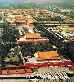
Tian'anmen Gate (Gate of Heavenly Peace) was built in the 15th Century and restored in the 17th Century. From imperial days, the yellow glaze-tiled double-eaves tower functioned as a rostrum for proclamations to the assembled masses. October 1, 1949, Chairman Mao Zedong proclaimed the founding of the new China. The tower has five doors and in front of it are seven bridges spanning a stream. Only the emperor could use the central door and bridge. On the top of the central door is a gigantic portrait of Chairman Mao with slogans on each side stating 'Long Live the People's Republic of China' and 'Long Live the Unity of the Peoples of the World'. Walking through the gate, you can enter the imperial city - Forbidden City with free charge while a panoramic view from the tower costs 15RMB for Foreigners.

Obelisk marble columns engraved with entwisting dragons and clouds - an ornamental architecture called Huabiao in front of the Tian'anmen
Huabiao

Right beside a pair of marble lions in front of the Tian'anmen Gate stand obelisk of marble engraved with entwisting dragons and clouds - an ornamental architecture called Huabiao. Its history can be traced back to the Yao and Shun, legendary kings in remote antiquity. To solicit public criticism, it is said that wooden crosses were erected at marketplaces for people to write down complaints. Later during the Han (206 B.C. -- 220 A.D.) wooden posts were replaced by stone pillars, which gradually became the sumptuous columns to palace gates. Huabiao can be usually found in imperial gardens and mausoleums.

On the top is a plate-shape flat called Chenglupan (dew-collecting) on which squats an animal called kong (a legendary animal for watch-keeping) facing to the south. They were called "Wangjungui" or "looking forward to the emperor's return," who watched over the emperor's excursions and called him back. The couple inside the gate facing north, called Wangjunchu or "looking forward to the emperor's progress," were considered to supervise the emperor's behavior in the court when he neglect court affairs.

Great Hall of the People

Great Hall of the People, in Tian'anmen SquareThis is the venue of the legislature, the National People's Congress. Summit meetings are often held in the 10,000-seat auditorium with the familiar red star embedded in a galaxy of lights in the ceiling. Also you can visit the 5000 seat banquet room where US president Richard Nixon dined in 1972. The admission costs £¤ 15.

Monument to the People's Heroes (Renmin Yingxiong Jinianbei)

Built in 1958 on the southern side of Tian'anmen Square, this 36-meter obelisk bears brass-relief carvings of key revolutionary events such as the Chinese destroying opium in the 19th century.

Mao Zedong Memorial Hall (Mao Zhuxi Jiniantang)

Behind the Monument to the People's Heroes is the hall where the embalmed body of Chairman Mao is kept and many Chinese show deep respect when confronted with the physical presence of Mao. more

Opening: 9:00 - 16:30


Google Maps,Google Maps coordinate,Only show at Item-Page.


位于北京城的中轴线上的天安门,始建于明永乐十五年(14l7年)。原名承天门,以示皇帝“承天启运,受命于天”。清顺治八年(1651年)重建后,改称天安门.既包含了皇帝是替天行使权力。理应万世至尊的意旨;又寓有“外安内和,长治久安”的含义。明、清时,天安门是皇城的正门,城门五阙,重楼九楹,高为33.87米;1970年翻建后高达34. 7米。它造型典雅,是我国传统建筑艺术的代表作。

天安门的主体建筑分为上下两层。上层是重檐歇山式,黄琉璃瓦顶的巍峨城楼,东西面阔九楹,南北进深五间,取“九五”之数,象征皇帝的尊严。正面有36扇菱花格式的门窗。城搂基座周围有汉白玉栏杆、栏板,雕刻着莲花宝瓶图案。城楼内所用木材大部分是楠木,60根红漆巨柱排列整齐,柱顶上有藻井与梁枋,绘着金龙吉祥彩画和团龙图案。地面铺的全是金砖,面积约2000平方米。屋顶的正脊与垂脊上装饰着螭吻、仙人、走兽。下层是高13米的朱红色城台,四周环绕琉璃瓦封顶的矮墙,下部是1.59米高的雕刻精美的汉白玉须弥座台基。城台的总面积达4800平方米,东西两侧各有一条长达百级供上下城楼用的梯道,俗称马道。还有5个拱形门洞,中间的门洞最大,高8.82米,宽5.25米,唯有皇帝可以进出。城楼前有外金水河,河上飞架7座汉白玉雕栏石桥,中间一座最宽阔的称“御路桥”。专为皇帝而设;御路桥两旁有宗室亲王过往的“王公桥”;王公桥左右的“品级桥”是供三品以上的官员行走的;四品以下的官员和兵弁、夫役只能走“公生桥”。公生桥架在太庙(劳动人民文化宫)和社稷坛(中山公园)门前。5座内金水桥除有类似严格的等级规定外,还表示“万方来朝”之意。金水河两岸有两对威风凛凛的石狮及两座连同须弥座高为9.57米的华表。石狮系明代永乐年间原物,距今已有500多年。石狮后面两边设有红色观礼台,台前东西各筑花坛,游人们常在这里驻足观景。华表上满刻着盘龙与云朵,巨柱顶端加上了云板、承露盘并蹲坐着石兽,此兽有注视皇帝出入之意,因而人们把前华表上两只背北面南的石兽叫“望君归”;把后华表上两只背南面北的石兽称“望君出”。

天安门在明、清两朝是皇帝颁发诏令之地。遇有新皇帝登基、大婚等重大庆典活动和皇帝父母进宫,都要启用天安门。皇帝平时一般不走天安门。只有每年去祭天、祭地、祭五谷时,才由此门出入。另外,皇帝御驾亲征或大将出征,都得在天安门前祭路、祭旗,以求马到成功,凯旋归来,同时显示威风。天安门还是“金殿传胪”的场所。每逢殿试后的两天,皇帝召见、传呼新中进士们的姓名,这叫“传胪”。考中前三名的状元、榜眼、探花插上金花,身披红绸,骑马游街,以谢皇恩。天安门唯独皇帝可以出入,而且只能出入喜事,绝对禁止出入丧事。

天安门是中华人民共和国举行开国大典的主会场,也是国徽图案的重要组成部分。它是我们伟大祖国的象征,已成为人们喜爱的观瞻胜地。more

The Forbidden City(故宫),Beijing

   The Forbidden City (Imperial Palace) in the heart of Beijing is the largest and most complete imperial palace and ancient building complex in China, and the world at large. Its construction began in 1406 and was completed 14 years later, having a history so far of some 580 years. Twenty-four emperors from the Ming and Qing (1644-1911) dynasties lived and ruled China from there. Most of the buildings in the Forbidden City were rebuilt many times, although they maintained the original architectural style.
  
   The Forbidden City, extending 753 meters from east to west, and 961 meters from north to south, makes a rectangular shape and covers a total area of 720,000 square meters. It consists of several dozen compounds of varying sizes and some 9,900 bays of rooms, with a total floor area of 150,000 square meters. Most of the buildings were built with wood, roofed with yellow glazed tiles and built on blue-and-white stone foundations, looking solemn and brilliant. City walls were 10 meters high, and a 52 meter-wide moat surround the Forbidden City. Three-storied towers are placed at each corner of the wall.
  
   The building arrangement within the Forbidden City is symmetrical. The Hall of Supreme Harmony, the Hall of Central Harmony and the Hall of Preserving Harmony, which comprise the outer palace, and the Hall of Heavenly Purity, the Hall of Union and the Hall of Earthly Tranquility, comprising the inner palace, stand in a line from south to north on the central axis. The 8 km central axis

runs through the
entire old Beijing
city to Yongdingmen in the south and
Zhonggulou in the north. The throne symbolizing imperial power is> positioned at the center of this
central axis.
  
   The buildings of the Forbidden City fully embody the artistic features and style of ancient Chinese palace architecture, and can be called a masterpiece in Chin
ese, even world, arch itectural history. Today, as the largest museum of cultural relics in China, the Forbidden City, also called the Palace Museum, collected and displayed some one million precious hist orical relics from the Shang Dynasty (16th century -771 BC) through to the Qing Dynasty. It was made part of the world cultural heritage list in 1987. more

Office of the Palace Museum Tel: 86-10-85117049
Google Maps,Google Maps coordinate,Only show at Item-Page.


故宫又称“紫禁城”,是明清两代的皇宫,也是世界上最大的宫殿,占地72万平方 米(长 960米,宽750米),建筑面积15万平方米,始建于公元1406,1420年建成,是明朝第皇帝朱棣始建,设计者蒯祥(1397—1481年,字廷瑞,苏州人),占地面积78万平方米,用30万民工,共建了14年,有房屋9999间半
,主要建筑是太和殿、中和殿和保和殿,保和殿也是科举考试举行殿试的地方,科举考试的一至三名分别称状元、榜眼、探花。

  故宫严格地按《周礼·考工记》中“前朝后市,左祖右社”的帝都营建原则建造,其前半部分为外廷,是皇帝朝政场所。建筑庄严、宏伟,特别是太和殿、中和殿和保和殿三大殿,建筑在8米高的三层汉白玉石阶上,以显示封建帝王至高无上的威严,太和殿座落在紫禁城对角线的中心,故宫的设计者认为,不这样不足以显示皇帝的威严,不足以震摄天下。

  现在我们参观时都为故宫的宏大而叹服,这一点在参观三大殿时感觉最明显,故宫是目前世界上最大的宫殿。

  午门是紫禁城的正门。东西北三面以12米高的城台相连,环抱一个方形广场。当中的正门平时只有皇帝才可以出入,皇帝大婚时皇后可以进一次,殿试考中状元、榜眼、探花的三人可以从此门走出一次。文武大臣按文东武西由两侧门出入。

  故宫参观的重点(必看):
  1、故宫中路外庭的三大殿(太和殿、中和殿、保和殿)、内庭三大殿(总长近一公里,走下来1个半小时);
  2、故宫西路(主要是养心殿,位于西路南端,从雍正开始清代8个皇帝在此居住,参观半小时);
  3、珍宝馆(在外东路,收藏有大量的故宫珍宝,票价10元,下午3点半停止售票,细看要3小时)more

Friday, October 06, 2006

HuangShan(黄山) Anhui

Huangshan Mountain in east China's Anhui province is one of Chinas ten best-known scenic spots, It is characterized by the four wonders, namely, odd-shaped pines, grotesque rock formation, seas of clouds and crystal-clear hot springs. Mount Huangshan is celebrated for having all the features of mountain scenery. Known as the No. 1 Mountain Under heaven, it features numerous imposing peaks(77 exceed an altitude of 1,000m), forests of stone pillars and evergreen sturdy pines; other features include grotesquely-shaped rocks (many of which are individually named, such as "pig-headed monk eating water melon"), waterfalls, pools and hot springs. Because of its mists and clouds, natural scenery in the area changes beyond prediction. Xu Xiake, a noted Chinese geologist and traveler in Ming Dynasty, praised Huangshan Mountain as the best of all mountains.

Mount Huangshan was listed as one of the World Natural and Cultural Heritages in 1990.

Mount Huangshan extends 40 kilometers from south to north and 30 kilometers from east to west, covering an area of 1200 square kilometers, the highlights of which occupy 154 square kilometers.
Huangshan Mountain is a marvel: within an area of 154 square kilometers there is a crowd of peaks, 72 of which have names indicating the shapes they resemble. Lotus, Brightness Top and Celestial Capital are the three major ones, all rising above 1,800 meters above sea level. The mountains are a body of granite, often with vertical joints. Erosion and fracture contributed to shape the rocks into huge columns, giving rise to lofty peaks and deep ravines. When it is cloudy the pinnacles loom in mists as if they were illusionary, while the sun is shining they unfold in all their majesty and splendor. Huangshan Mountain change its color and appearance with the alternation of seasons. In spring blooming flowers decorate the slopes in a riot of color and fill the valleys with fragrance; in summer you see verdure peaks rising one upon another and hear springs gurgling merrily. Autumn dresses the mountains in red and purple as maples and some other trees are blazing-red; winter turns them into a world of frost and ice with silver boughs and rocks everywhere. Here in Huangshan, pines and rocks are intimately involved with each other, almost every rock has a pine tree growing out of the crevice, and every tree has tortuous and gnarled roots and branches.The still sea of snow-white cloud can suddenly begin to roll and toss, rise or fall, gather or disperse while the peaks emerge and disappear in the clouds like isles in the ocean. So from ancient times it has been frequented by tourists seeking their mystery and admiring their frequented by tourists seeking their mystery and admiring their scenery. They come to the conclusion that the fantastic pines, the grotesque rocks, the sea of clouds and the hot springs are the four major attractions of the Yellow Mountains. As a matter of fact there are marvels almost everywhere, especially in the following scenic areas: Wenquan (Hot Spring), Yupinglou (Jade Screen Tower), Xihai ( West Sea), Beihai (North Sea), Yungusi (Cloud Valley Temple) and Songgu'an (Pine Valley Nunnery).

There is plentiful rainfall in Huangshan Mountain. Therefore there are thick forests.Owing to the peculiar terrain, the Huangshan Mountain's climate is marked by a vertical change, and the vertical distribution of vegetation is also distinctive: plants on the summit, on the middle levels and at the foot belong to the frigid, temperate and subtropical zones respectively. There are more than 1500 species of plants, of which trees comprise one third. So the Huangshan Mountain occupy an important place in China's botanical research. Here you will find century-old pines, firs, ginkgoes, actinidia, Chinese torreyas and camphor woods, remnants of the glacial era. A number of trees are celebrated on account of their age, grotesque shape, or precipitously perched position. Mount Huangshan abound in flowering plants; many of them are rare ones, such as Huangshan Rhododendron, magnolia as well as azalea, camellia, plum, lily, orchid, and so on. It has a rich store of medicinal herbs; more than 300 kinds are found here; the notable ones being glossy ganoderma ginseng, Chinese gold thread rhizome and Chinese cinnamon. Maofeng tea of Huangshan is well known at home and abroad.

Huangshan Mountains also provide the natural habitat for a wide variety of fauna. Among the animals there are monkeys, goats, deer, pangolin and squirrels. There are rare birds such as the red-billed leiothrix, the silver pheasant, the octave-tone bird and the oriole, all good singers. The red-billed leiothrix (called "love birds" in Chinese) are so lovely that they have become favorites of foreign tourists and are exported by pairs. Besides, chukkar(stone frog) from the streams is good to make delicious dishes with.

Mt. Huangshan's climate is mild and humid, neither too hot in summer nor too cold in winter, the temperature is agreeable all the year round .
It is cool in summer, averaging 70 °F at the North Sea Area ( 1 ,630 meters above sea) and 80 °F at Hot Spring Area (630 meters above sea) in July (the hottest month). As clouds often shut out the sun, hot weather never stays long, and this makes Yellow Mountains an ideal summer resort.
Mt.Huangshan lies in subtropical zones, so it's not quiet cold in winter, at least, not so cold as some people expected. The temperature ranges from 25 °F to 40 °F, but it's enough to result in a fantastic snow scenery and a silver world with pines and precipitous peaks covered with snow and decorated with icicles

Today Mt. Huangshan has become a world-famous tourist attraction. With its convenient facilities: three cable lines, four three-star hotels on the top, all the paths paved with flat stones, it lures millions of visitors both from home and abroad. Seeing is believing. Welcome to Mount Huangshan. More


add:Google Maps,Google Maps coordinate

黄山雄距于风景秀丽的皖南山区,它以“三奇四绝”的奇异风采名冠于世。1982年黄山被国务院列为首批国家级重点风景名胜区,1986年经评选列入中国十大风景名胜区,1990年被联合国教科文组织列入“世界遗产”名录。此后,黄山又相继被评选为国家级“卫生山”、“安全山”,1998年被建设部、国家旅游局等部门确定为全国首批十个文明景区之首。

  黄山,古称黟山,唐天宝六年(公元747年)依轩辕黄帝曾在黄山炼丹羽化升天的传说,唐明皇敕改黟山为黄山。它地跨市内歙县、休宁、黟县和黄山区、徽州区,面积1200平方公里,现划入黄山风景区的154平方公里,是号称“五百里黄山”的精华部分。

  黄山是以自然景观为特色的山岳旅游风景区,奇松、怪石、云海、温泉素称黄山“四绝”,令海内外游人叹为观止。黄山有名可数的72峰,或崔嵬雄浑,或峻峭秀丽,布局错落有致,天然巧成。天都峰、莲花峰、光明顶是黄山的三大主峰,海拔高度皆在一千八百米以上,并以三大主峰为中心向四周铺展,跌落为深壑幽谷,隆起成峰峦峭壁,呈现出典型的峰林地貌。

  登上一千八百多米的高处纵览,山中奇峰汇聚,峭壁千仞,拔地擎天,峥嵘崔嵬。青松在悬崖上争奇,怪石在奇峰上斗艳,烟云在峰壑中弥漫,霞彩在岩壁上流光,自然的美在这里汇聚,在这里升华,赋予它超凡脱俗的品质,塑造出它威武雄壮的气概。在黄山的面前,时空变得狭小,沧桑变得平淡,它是大自然的骄子,独领天下奇山的风骚。故而当之无愧地赢得“登黄山天下无山,观止矣”(徐霞客语)的崇高赞誉。More

Thursday, October 05, 2006

Jiuzhaigou(九寨沟)

Known as the "Fairyland on Earth" . Jiuzhaigou sits on 103° 46' –I04° 4 ' E and32° 15 ' -33° 19' N, within the boundary of Jiuzhuigou County , Aba Prefecture , Sichuan . It lies between the southwest margin of the Qinghai-Tibet Plateau and at the north foolt of Duo'ema Mountain Range, with an average , altitude between 2, 000 and 3,000 meters, and a distance of about 435 kilometers from Chengdu , the capital city of Sichuan Province .

To its east, Jiuzhaigou neighbors both the Baihe River Nature Reserve and the Wanglang Nature Reserve , and to its south is the Huanglong Place of Scenic Interest . Jiuzhaigou covers a total area of 720 square kilometers, with a periphery zone of 600 sq. m. and a buffer zone of 110sq. m.

Jiuzhaigou, also called "Yangtong" in ancient times, cur- rently has other names like "Heyao Jiuzhai", and the " Jade Sea ". Jiuzhaigou, literally the Nine Village Valley , is hence known for the nine Tibetan villages within its boundary, that is, Panxin, Rize. Yacuo , Panya, Zechawa , Heijiao, Shuzheng, Heye and Zharu. The area of Jiuzhaigou as well as the upper reaches of the Jialing River and Minjiang River are called the land of Shiqiang (Qiang ethnic minority ) in aocient times, where human activities have been recorded dating back as early as to o the Yin-Shang Period (16th- 11th Century B. C.). Ac- cording lo The Records afSongpan (vol. I - Rivers and Mountains), the "Jade Sea is 50-odd kilometers to the northeast county, within the territory of Zhongyang Tongfan Tribe. Its valleys are as long as several kilometers with green water and jade-like ripples." This evidences that the Jade Sea beauty was well known as far back in ancient times.

Jiuzhaigou covers the Shuzheng Valley . Rize Valley and Zechawa Valley that take a "Y" shape, in the Minshan Mountain Range. Inhabited by Tibetans, the nine vil- lages and alpine lakes, affectionately called "Ham", are like reflecting mirrors or crystal jade blocks inlaid in snow mountains and forests. At the end of Zechawa Valley is the Chang (Long) Lake and the end of Rize Valley are virgin forests. From .south to north, both val- leys stretch and meet al Nuorilang. The drop between the two valleys and Shuzheng Valley is over 1,000 meters, with 1 14 lakes lying downward in an echelon manner, on which arc 17 waterfalls, 11 rip currents and 5 travertine beaches, formulating alpine lake clusters and travertine spots that are rarely seen in China and even in the world. A fairyland on earth. Jiuzhaigou col- lects the primitive, natural beauties best demonstrated in its lakes, waterfalls, beaches, water currents, snow peaks, virgin forests and Tibetan customs. more

Magic Mirror Cliff
It's a gigantic cliff rising 800 metres from the level ground. Its surface is as smooth and slippery as a mirror. Capped with pines and China firs, the cliff top resembles a human head with cropped short hair and curly beard, which in local mythology, was left over by Zhayiga, the Ancester of mountains to keep the evil spirit under control.

Penjinghai Lake (Miniature Landscape Lake)
On the Lake's shallows, a few dozens of miniature-potted-landscape-like bushes of azalea, poplar, metasequoia etc. scatter about. They assume various forms: some in the shape of a fierce spread eagle, and some, of a galloping steed.

Luweihai (Reed Marshes)
It is 1375 metre long and over-grown with reeds. A clear brook zigzags its way through the marshes, where waterfowls are seen hovering overhead. When the season turns, the green meandering brook presents a striking contrast with the yellow spread of reeds.

Huohahai (sparkling Lake)
The west hill commands a spectacular view of the sparkling reflections of bright sunlight upon the Lake's deep blue surface. Lying Dragon Lake: In the middle of the lake, submerges a dimly visible yellowish "Lying Dragon" in some 20 metre deep water. When a gentle wind from the mountain whips up ripples on the Lake's clear surface, it looks as if the "Dragon" were stretching herself, and once the wind increases intensity, the "Dragon" begins to shake her head and wag her tail, as if poising for a take off.

Shuzheng Group of Lakes
It consists of some 40 large and small inter-connected lakes stretching as long as ten Li. The waters overflow the inter-lake banks of calcic soil over-grown with willows, pines and cypresses and become a succession of waterfalls. The nearby Shuzheng stockaded village still preserves two primitive stone mills and one wooden bridge, They are simple and rough, but very charming.

Nuorilang waterfalls
A massive water current washing over a cliff top over-grown with willows, drops some 30 metre down and form spectacular waterfalls of various size and shape. Some waters fall straight down to the ground. Some dash against protruding rocks midway and explode into millions of colorful tiny beads.

Pearl Shoal
A stream rushes down a 20 degree slope into the Shoal splashing water about like millions of bouncing silver pearls and then goes on down to form fantastic waterfalls of various shape with thunderous roars echoed by the deep valley.

Wuhua Hai (Five Flower Lake)
Due to different water depths and silts on the bottom, the Lake's waters assume a variety of colors, such as light yellow, dark green, deep blue, jadeite, under the sun light, they are as colorful and beautiful as a peacock's feathers.

Panda Lake Waterfall
It consists of 3 waterfalls with sizes of 5x19m., 2x24 m., and 14x19 m., respectively. Three separate streams rush down a precipice and form waterfalls with multiple sections of 65 m, in total height.

Swan Lake
It's 2250 m. long and 125 m. wide (at maximum) encompassing an area of 142.8 mu . The surface is domed with weeds and wild flowers. It's a tranquil and secluded place frenquented by swans and wild ducks.

Hanging Dagger Spring
Overlooking the Swan Lake is a solitary Lofty peak, 500 metre high and resembling a dagger piercing through the sky. From the halfway down the peak, voluminous waters gash out and drop some thousand feet like a white chain hanging in the air.

Five Color Pool
Filled with crystal-clear waters the pool looks colorful, radiant and fascinating.

Long Lake
It's the largest lake in Jiuzhaigou Valley, covering an area of 7.5 km, long and 0.375 km. wide. It is 3103 metres above sea level, with a maximum depth of 103 metres. The melted snow from the South Peak and the waters of surrounding mountain streams and brooks all find their way into the Lade which has no exit. The excess water either vapours or seeps into the earth. The waters never spill over the banks in spite of downpours in summer and autumn. The Lake won't dry up either in spring and winter, even there's a long dry spell. In spring, Jiuzhaigou Valley is radiant and enchanting. The air is filled with fragrance of wild blossoms. In summer, the beautiful trees are luxuriantly green. In autumn, the breeze is intoxicating, while tree leaves turn crimson. In winter, the mountains and valleys are wrapped in snow and ice.


九寨沟风景名胜区位于四川省阿坝藏族羌族自治州南坪县境内,距离成都市400多公里,是一条纵深40余公里的山沟谷地,因周围有9 个藏族村寨而得名,总面积约620平方公里,大约有52%的面积被茂密的原始森林所覆盖。林中夹生的箭竹和各种奇花异草,使举世闻名的大熊猫、金丝猴、白唇鹿等珍稀动物乐于栖息在此。 自然景色兼有湖泊、瀑布、雪山、森林之美。沟中地僻人稀,景物特异,富于原始自然风貌,有“童话世界”之誉。有长海、剑岩、诺日朗、树正、扎如、黑海六大景区,以翠海、叠瀑、彩林、雪峰、藏情这五绝而驰名中外。

  九寨沟处于四川盆地向青藏高原过渡的边缘地带,属松潘、甘孜地槽区,恰好位于我国第二级地貌阶梯的坎前部分,在地貌形态变化最大的裂点线上,地势南高北低,有高山、峡谷、湖泊、瀑布、溪流、山间平原等多种形态。其地貌属高山狭谷类型。山岭的海拔高度大都为 3500-4500米,最高峰嘎尔纳峰海拔4764米,最低点羊峒海拔2000米。整个景区内沟壑纵横,山峦叠嶂,好似大自然撰写的一部壮丽史诗,记录着地壳的沧桑变迁和生命的进化历程。

  在传说中九寨沟是仙女的宝镜幻化而成,优美的故事带给人梦幻般的想象。但从科学的角度看,九寨沟翠海叠瀑的形成,则是由于地壳变化、冰川运动、岩溶地貌和钙华加积等多种因素造就的。

  九寨沟地处四川盆地向青藏高原延伸的过渡带,为多种自然要素交汇地区。山地切割较深,高差悬殊,植物垂直带谱明显,植被类型多样,植物区系成分十分丰富。区内有高等植物2576种,其中国家保护植物24种;低等植物400余种,其中藻类植物212种,且40余种属四川首次发现,为九寨沟独有。许多古老的孑遗植物保存良好,波士曼博士称“九寨沟是个丰富多彩的博物馆,是实力雄厚的基因库。”

  九寨沟海拔高差大,地形地貌复杂,植被类型丰富,保留有大面积的原始生态环境,为不同类型的动物提供了适宜的栖息环境。湖面,野鸭水鸟起落;林中飞禽走兽云集。据有关部门粗略统计,生活在这里的野生动物,已知的就有近300种。其中被列为国家重点保护的珍稀动物27种,如大熊猫、金丝猴、牛羚、白唇鹿、黑颈鹤、天鹅、鸳鸯、红腹角雉、雪豹、林麝、水獭等,九寨沟堪称动物王国。

Monday, October 02, 2006

Putuoshan(普陀山)


Located on the Lianhua Ocean of Zhoushan Archipelagoto the east of Hangzhou GuIf,Mount Putuo covers an area of only 12.5 square kilometers. There are many wonderful scenic sites on the island,including" Temples and Nunneries”“Golden Sands"," Exotic Rocks","Tide Sounds and "Mirage" which are callad Five Putuo Beautie,and" Lotus Pool's Night","Pantuo Evening GIow"," Duanyin Sacred Site" etc.which are caIled Ten Famous' Sites. So it is known as " the Buddahist Kingdom amidst the Sea and Sky" Mount Putuo.It is one of China's four Buddhist Sacred Mountains has a long history in 916 A.D. it began toenshrine Guanyin ,and in1214,it was designated to perfom Buddhist rites especially enshrining Guanyin.The main scenic spots are three large temples named PujiFayu and HuijiPurple Bamboo Forost Da Cheng Monastry Guanyins Footstep and mount Luojia. There are Over 50O monks and nuns In the mountain.and pilgrims over one million evey year. On Guanyins Three Festivals(19th of Februarv, June and September In Chinese lunar calendar),pilgrims gather here like tide
more @ putuoshan.gov.cn & putuoshan.net

Sunday, October 01, 2006

Lijiang Yunan(丽江-云南-中国)

Location: located between 9923' - 10131' east longitude and 2559' - 2756' north latitude, and northwest of Yunnan province, middle reaches of Jinsha River
位置:位于西经9923' - 10131'北纬2559' - 2756',云南省西北方。

Neighboring Areas: Sichuan province and Guizhou province; Tibet Autonomous Region and Guangxi Zhuang Autonomous Region

Physical Features: lies in the joint area of Qingzang Altiplano and Yungui Altiplano

Nationalities: Han, Lisu, Pumi, Nuosu, Tibetan and Naxi

Geographic Feature: an intimate mountain town of stone and tile, laced with swift canals; a gathering place of rugged mountain people from various ethnic groups of Naxi Lisu, Pumi, Nuosu Yi, Tibetan

Climatic Features: distinctly vertical temperature difference, sufficient rainfall and clear division between dry seasons and humid seasons

Average Temperature: 12.6C -19.8C
Rainfall: annual average rainfall adds up to 1000mm

Mountains: Mt. Laojun, Jade Dragon Snow Mountain
Rivers: Jinsha River, Lancang River

Local Highlights: The Life of Naxi Women, Naxi Ancient Music, Old Town
丽江古城形成于宋末元初,明清以来一直是滇西北商贸中心和连接滇、川、藏的茶马古道重镇,已有800多年历史,面积3.8平方千米。古城北靠金虹山,西倚 狮子山,东南向着千顷沃野,气候舒适宜人。玉河水在玉龙桥下一分为三,入城后分成更多的支流走街过巷、穿墙进院流遍全城,富有小桥流水人家的审美情趣。街 道和房屋布局以水为脉随势自然,与内地城市方正严整的布局迥然不同,五花石路面色彩斑斓,融汉、白、藏等民族建筑文化的纳西民居古朴厚重保存完好,天井铺 地、门窗隔扇等古风犹存,具有较高的欣赏和研究价值。overview

Saturday, September 30, 2006

Lushan

Lushan is situated in the southern part of Jiujiang city in Jiangxi Province. Solitary and imposing, it towers over the southern bank of the Yangtze River, leaving behind its shadows upon the Boyang Lake. Nature has excelled herself in such a spectacular lone mountain. As a result of tremendous rubbing and grinding of glaciers, its grotesque peaks and cragged cliffs look all the more precipitous. The enveloping clouds and mists make it very hard to define the true shapes of the billowing peaks and ridges. The rapid streams cascade down and form numerous deep pools and hanging waterfalls. The lush mountain alongside with a crystal clear glimmering lake is picturesque. Mysterious and enchanting sceneries nestle in the secluded valleys and deep ravines. To describe the infinite variety of fantastic shapes of Lushan Mountain, Sudongpo (a famous Chinese ancient poet) wrote in his poetic masterpiece:" I can't tell the true shape of Lushan, because I myself am in the mountain!"


Dragon Head Cliff
Besides a craggy cliff, it springs up some thousand feet out of the ground, rearing in the sky like a dragon head. From top down, it's inlaid with protruding grotesque stones and overgrown with upside down pines. Standing at the top, one can enjoy a bird's eye view of the Tiechuan Peak and hear the surfing of wind in the pine forest mingled with roaring of the waterfalls in the Stone Gate Ravine.

Three Tier Spring
Originating in Dayue Mountain, the spring angles around the backside of Wulaofen (Peak of Five Old Men) and pours into Jiudiego (Nine Tier Gully), crashing twice upon huge rocks, and then converges into a torrent, and drops once again, splashing and throwing about millions of water beads. Driven by the gully wind, the tiny drops dance in the misty air, sparkling in the sunlight, and falling like countless dazzling pearls.

Huangshan

Situated in the southern part of Anhui Province in China, Huangshan (Yellow Mountain) is a famous scenic spot. On the mountain, the peaks rise one upon another and the pines and cypresses are luxuriantly green. Among the 72 big and small mountain peaks and ridges, the lakes, brooks, deep pools and waterfalls can be found everywhere. All over 1800 metres above sea level, and shrouded in clouds and mist, its main three peaks: Lotus Flower Peak, Ever Bright Peak and Heavenly Capital Peak present a scenery of boundless variety. Huangshan owes its unique scenic value to four factors, i.e. queer pines, grotesque rocks, cloud seas, and a hot spring. The exquisite scenery varies with the various seasons. Most spectacular are blossoms in Spring, pools in Summer, forests in Autumn and snow in Winter. In 1990, the UNESCO listed Mt. Huangshan as "A World Cultural And Natural Heritage."

Heavenly Capital Peak
Located in the south-eastern part of Huangshan, and 1810 metres above sea level, it is the most perilous peak of the three. The path to the top is via a vertical ladder inlaid in a precipitous cliff, and fenced in with stone posts and iron chains. The last section of the path to the top is about 30 metre long and 1 metre wide hunch-backed rocky ridge rising up from a deep ravine. Due to its riskiness, in spite of protections provided by the stone posts and iron chains it is figuratively called "Silver Carp's Back." On the summit, there is a stone cave large enough to seat a hundred people. Near the cave entrance, lies a rock resembling "A Drunkard Immortal Reclining On His Side" who was as if assigned to guard the gate of the cave. The summit commands a distant view of misty ranges of mountains and rivers diminishing into tiny lines. Here, one is at last at "the Peak of Perfection" as the inscription on a rock close at hand reads.

Lotus Flower Peak
Situated in the centre of Huangshan, and 1886 metres above sea level, it is the highest one of Huangshan's three main peaks. Lofty and precipitous, its principal peak towers over a number of smaller ones around it. The summit area is only a few square metres. Standing on it, one is as if to assume the dauntless spirit of propping up the sky from falling down. Far ahead in all directions are myriad of mountains vying with one another for beauty, and streams and rivers competing to be the fastest.

First Belief Peak
It is located in the eastern part of Huangshan, and 1668 metres above sea level. The peak is famous for exquisite rocks and graceful pines. With its three sides being precipitous and fathomless cliffs, First Belief Peak, flanked by Rising Peak and Stalagmite Peak as Fairy Bridge spans the summit. A poetic inscription on a rock there reads "you are a lone climber from a freezing river."

Wudalianchi

Wudalianchi (Five Big Linking Lakes) is situated in the northern part of Dedu County, Heilongjiang Province, to the western foot of Xiao Xinanling Ridge and on the upper reach of Bai River, branch of the Nemoer River. It has five lakes with one wave reflecting the other, one lake linking the other, meandering forward. People call it Wudalianchi, a famous scenic spot of the nation.

Group Volcanoes: Surrounding the Wudalianchi there spot scores of volcanoes, rising sheer from level ground, layer upon layer and range upon range, a grand and magnificent scene. In the long geologic age, a series of long, consecutive and intricate geological functions formed 11 "shield shape volcanoes", 14 "compound volcanoes" and large scale lava.

Group Mineral Springs of Medicine: The more interesting thing in the Wudalianchi is that one can drink to his heart's content the mineral water, which is called generally "mineral water of heavy carbonate". It contains more than ten elements beneficial to health, which have certain curative effect for stomach trouble, iron deficiency anemia, chronic cholecystitis, neurasthenia, skin disease, and high blood pressure, focuses etc.

Wudalianchi mineral spring consists of North Spring, South Spring, New South Spring, South Bathing Spring and Fanhua (Seething Waves) Spring, which are scattered on the area of Yaoquanshan (Mountain of Medical Spring). North Spring, South Spring and New South Spring are drinkable while South Bathing Spring and Fanhua Spring are bathing ones.

Heilongshan (Black Dragon Mountain) is one of the youngest volcanoes in Wudalianchi. On the south slope of it, there are two limestone caves; Water Screen Cave and Fairy Palace (cave). During monsoon season, the Water Screen Cave can form and Fairy Palace (cave). During monsoon season, the Water Screen Cave can form a screen of drizzling water, inside which there is coolness and quietness. The depth of the Fairy Palace is of tens of meters, crooked and winding, the bottom of which is covered with hard ice all year round, nip in the air, mysterious and unfathomable. On the north slope of Heilongshan, there is a broad valley which was the place the scorching hot lava flowed through in those years. The dense forest of pine and white birch trees grows in the valley casting thick shadows all around, with birds chirping. Besides, there are reddish brown volcano conglomerate and ashes, but green moss and lichen grow luxuriantly. The long cane twines round twines round trees large air smells moist and fresh with valley spreading forth vitality.

Huanglong

Situated on the middle of Minshan Mountain ranges northeast of Songpan County, Sichuan Province, Huanglong Scenic Area is a state first-class scenic zone, reputed as "Jasper Lake on Earth".

Colorful Lakes Reflecting azalea flowers: They are groups of colorful lakes surrounded by azalea shrubs. Innumerable red and green exotic azalea blossoms sparkle lustrously upon the surface of the lakes.

Zhengyanchi (Lakes Vying with One Another for Beauty): It's the largest group of Huanglong colorful lakes. They vary with one another in size, shape and color. Under the brilliant sunlight from different angles, the Lakes glow alternately with a variety of color: light blue, dark green, light yellow, bluish green, dark blue etc. Viewed from afar, they resemble a spread tail of a peacock.

Back Temple of Huanglong: In Huanglong, there are three temples: the front, middle and back, at an interval of 2500 meters. The Back Temple, basically in good shape was constructed at the end of the Huanglong Gully, with Yucui Peak at back, encompassing 2100 square meters. The buildings, simple and in good taste are of wooden structure with a courtyard and green-tiled roofs. On the lintel of the entrance gate are hung two parallel boards. The upper board is inscribed with the Chinese characters of "Huanglong Ancient Temple", on the middle, "Flying Pavilion Glowing Vermilion" on the right, and "Clear Mountain and Blue Water" on the left. The lower board is inscribed with "Distant Bosom Hearts are Linked" in vigorous and simple calligraphy. One of the two antithetical couplets in the Temple goes: "The Howling of Wind, Pitter-pattering of Rain, and Chiming of Bells, Every Sound is Real; The color of Mountain, The Color of Lake and the Color of Sunrays, All Colors are Illusory." The Grand Hall houses a statue of the True Man of Huanglong in the center. The Temple is encircled by broad lawns.

Huanglong Cave: The Cave entrance is surrounded by azalea shrubs. 10 meters from the entrance, the Cave broadens into a spacious hall, 20 meters high and 50 meters wide. The Cave contains numerous minor caves of various size and shape, which are hard to explore. There are three life-size stalactites resembling seated statues of Buddha.

Wulingyuan

Wulingyuan Scenic Area spreads out among Wulingyuan Mountains in Zhangjiajie city, southwest of Hunan province. It is about 400 kilometers (248.56miles) away from Changsha, the provincial capital. The whole area includes four parts: Zhangjiajie National Forest Park, Yangjiajie Scenic Spot, Suoxiyu and Tianzishan Natural Resources Reserves with an area of 500 square kilometers (193 square miles). Owing to the neighboring plateau southwesterly of it and Dongting Lake to the east, the second biggest fresh water lake of China, Wulingyuan Scenic Area comes into being under interaction of land elevation and depression and the cutting force of flowing water. It presents a unique landscape of high mountains, grotesque peaks, beautiful waters, deep gorges, marvelous caves and exuberant forest.

Long since, Wulingyuan was kept in oblivion because of being hidden in hinterland of the province. It was until 1979 that Mr. Wu Guanzhong, a famous Chinese painter, discovered this magic land. In 1992, UNESCO inscribed it Wulingyuan on World Heritage List.

Zhangjiajie National Forest Park

Zhangjiajie National Forest Park comes up as the first of its kind in China in 1982. It lies in the southwest part of Wulingyuan Scenic Area. There grow over 1000 kinds of plants with coverage of approximately 97.7% of the total area. Among them, the rarities are gingko, sequoia and Yunnan catalpa. It also provides a best homeland for hundreds species of vertebrates, like clouded leopard, tarpon, macaque, giant salamander, pangolin, etc. Its scenery is known for grotesque peaks. Three thousand sandstone peaks, posing in various ways, make up a forest of peaks and shape the land into a natural labyrinth. Eight hundred streams crisscross through the valley with springs and waterfalls interspersed all around.

Suoxiyu Natural Resource Reserve

The land of Suoxiyu marks transitional zone of sandstone and limestone area, so the mountains here are not as cragged as those in Zhangjiajie Park. They do not stand out solitary, but outstretch one after another, like an unfolding scroll of Chinese painting. Besides the peculiar peak and beautiful water, Suoxiyu has its distinct features in bridges and caves. Constructed upon steepy cliff, bridges are noted for their risky location. Most of them were merely piled up by blocks of rocks that dovetailed perfectly by human works. Meanwhile the limestone caves create fascinating underground palace. There are altogether 59 caves full of queerly and differently shaped stalactites and stalagmites.

Tianzishan Natural Resource Reserve

Tianzishan is located in the north of Wulingyuan area, bordering on the south with Zhangjiajie and joining Suoxiyu to the east. It offers a panoramic view due to its higher location than other areas. Its major peak rises 1250 meters (4101feet) above the ground.

Minorities

West of Hunan province, it boasts a rich and special minority culture. In Zhangjiajie city, there live more than 20 minority groups, like Tujia, Bai, Hui, Miao, etc. During the long-time evolvement of civilization, they bring out a set of customs and traditions of their own style, including living habits, funeral and marriage systems, religions, and arts. For example, the Hand-Shaking Dance of Tujia minority, the Drum Dance of Bai, dragon dance of Miao are most representative. Villages of Miao or Tu minority people can be seen with groups of amphibious storied-houses. This kind of house is usually built up of wood or bamboo and typical of the subtropical area in China, like Zhangjiajie, where the climate is subject to monsoon with annual average rainfall of 1.382 millimeters.

Tibet Geography

Tibet, a rich and beautiful land, is located at the main part of Qinghai-Tibet plateau, south-West frontier of China. Tibet borders with Sichuan, Yuannan, Qinghai And Xinjiang; to the south contiguous to India, Nepal, Sikkim, Bhutan and Burma, and bounded by Kashmir on the west.

When the word Tibet is mentioned something icy chils the readers' nerves. In fact it snows only once or twice in a year and owing to the perpetuity of bright sunshine, it is not at all cold during the daytime even in the coldest of the winter. Tibet is so sunny that it produces a year-round sunshine of over 3,000 hours in a year. Its old name-"land of snow" - the name by which Tibet is almost popilary known as, is always thickly covered with snow with hardly any signs Of inhabitation. In fact, it is correct only when it is referred to the world greatest ranges located in Ima, the Tisi, and like. These ranges, run by leaps and bounds across the country showing their beautiful snow covered peaks against the bluest of skies.

Geographically, Tibet can be divided into three majoy parts, the east, north and south. The eastern part is forest region, occupying approximately one-fourth of the land. Virgin forests run The entire breadth and length of this part of Tibet. The northern part is open grassland, where nomads and yak and sheep dwell here. This part occupies approximately half of Tibet. The southern and central part is agricultural region, occupying about one-fourth of Tibet's land area. with all major Tibetan cities and towns such as Lhasa, Shigatse, Gyantse ad Tsetang located in this area, it is considered the cultural center of tibet. The total area of the Tibet Autonomous Region is 1,200,000 square kilometers and its population is 1,890,000. The region is administratively divided into one municipality and six prefectures. The municipality is Lhasa, while the six prefectures are Shigatse, Ngari, Lhaoka, Chamdo, Nakchu and Nyingtri(kongpo). The People's Government of the Tibet Autonomous Region exercises the hightest adminis-trative authority in Tibet.link

Tags